
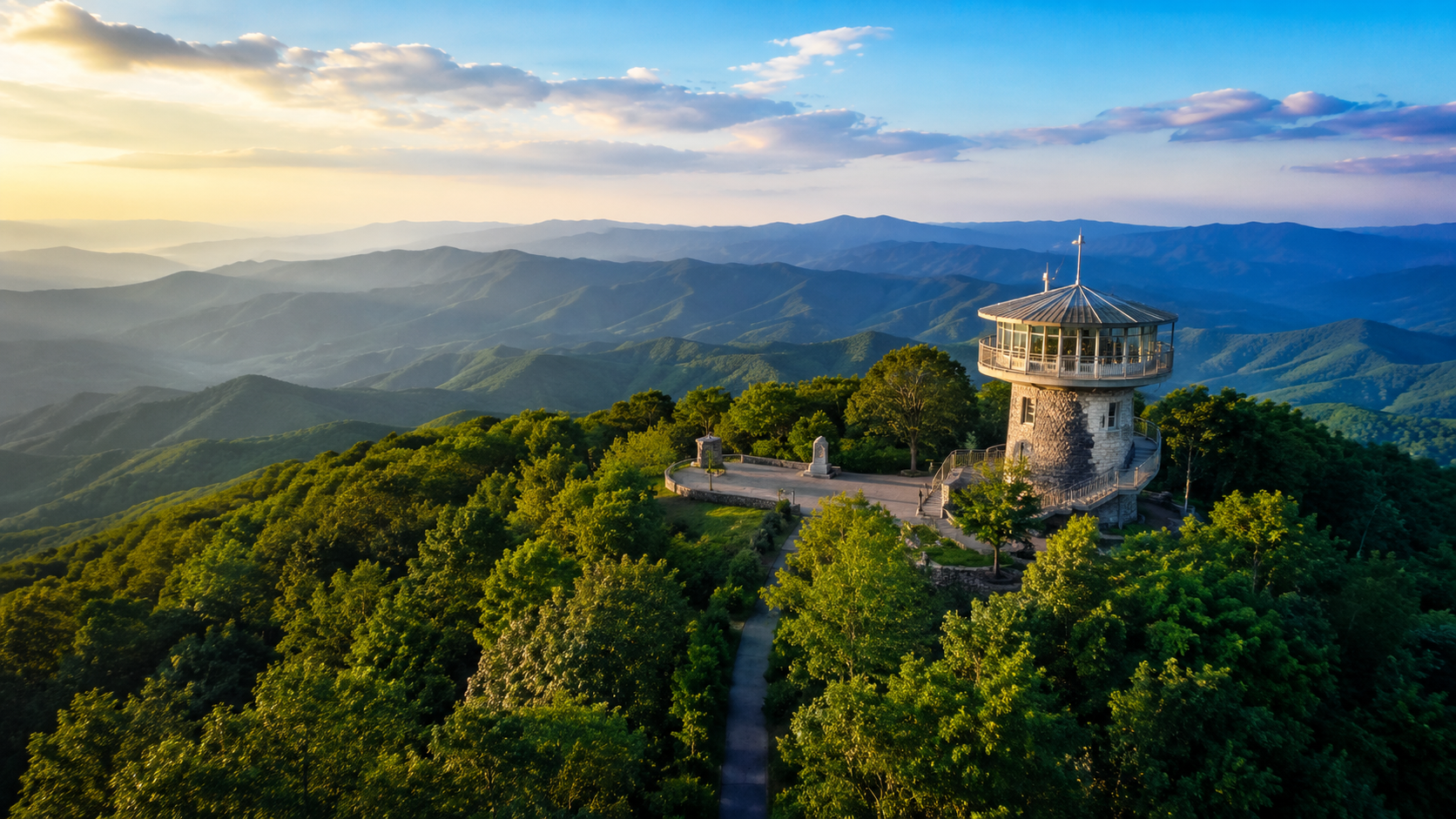
On a clear day from the top of Brasstown Bald, you can see four states stretching away beneath you — Georgia, Tennessee, North Carolina, and South Carolina — from a glass-walled observation deck nearly 4,800 feet up. Brasstown Bald is Georgia's highest point, rising 4,784 feet within the Chattahoochee-Oconee National Forest near Blairsville and Hiawassee, and it's one of the most rewarding easy adventures in the region. A short, steep trail or a shuttle takes you to the summit, where a visitor center, museum, and 360-degree views await. Here's how to plan a visit to the roof of Georgia. It's the kind of place that rewards both the casual sightseer and the serious hiker, and the sweep of the view from the top — ridgeline after ridgeline fading into the haze — is the sort of thing that stays with people long after they've driven back down. Few places let you take in so much of the Southern Appalachians from a single spot, and fewer still make it so accessible to nearly everyone who makes the drive.
Key Takeaways
- Brasstown Bald is Georgia's highest point at 4,784 feet, near Blairsville and Hiawassee.
- The summit offers 360-degree views of up to four states on a clear day.
- Reach the top via a short, steep paved trail (about half a mile) or a shuttle from the parking lot.
- A visitor center, museum, and observation deck sit at the summit.
- The site is seasonal (roughly spring through fall) with a fee — confirm hours and shuttle status before you go.
Where is Brasstown Bald, and getting there
Brasstown Bald straddles the line between Towns and Union counties in northeast Georgia, within the Chattahoochee-Oconee National Forest, roughly 12 miles from Blairsville and 9 miles from Hiawassee. It's an easy drive from the North Carolina line, which puts it within reach of a day out from Murphy or the lakes — and about an hour and a half north of Atlanta. The approach is via Georgia State Route 180 and the 180 Spur at Jack's Gap, and the final stretch up to the parking area is steep and winding, so take it slowly, especially in poor weather. The mountain is known to the Cherokee as Enotah, and it shares its name with the small community of Brasstown that sits just across the state line in North Carolina. Confirm current drive times and directions for your route, and note that the access road can be affected by winter weather.
Reaching the summit: trail or shuttle
From the parking area, there are two ways to reach the summit, and the right one depends on your group:
- The Summit Trail — a paved path of about half a mile to the top. It's short but genuinely steep, a real climb rather than a stroll, and rewards the effort with the satisfaction of walking up Georgia's highest peak.
- The shuttle — a bus runs between the parking lot and the summit for those who'd rather skip the climb, making the views accessible to nearly everyone.
The shuttle typically pauses around midday and stops running in the late afternoon, so check the current schedule. Either way, the summit itself involves a short walk and some steps, and the elevation makes it noticeably cooler than the valleys — bring a layer even in summer.
At the top: views, museum, and more
The summit is more than just a viewpoint. A circular visitor center houses a natural-history and cultural museum with interactive exhibits, and a short film plays in a mountaintop theater, telling the story of the mountain through its seasons and dramatic weather. The observation deck wraps the building with a 360-degree panorama, and informational panels help you identify the peaks, valleys, and landmarks spread out below — on the clearest days, even the distant Atlanta skyline. There's a gift shop with locally made products at the base, and picnic areas with views. Several hiking trailheads also begin near the parking lot for those wanting a longer outing, including routes that connect toward the Appalachian Trail. It all makes Brasstown Bald a destination that suits everyone from casual sightseers to serious hikers, and a natural pairing with a day spent around Blairsville or the lakes.
When to go and what to know
A little planning makes a Brasstown Bald trip smooth. The visitor center and shuttle operate seasonally — generally spring through fall, often around spring through December, weather permitting — and the facility may close in winter due to snow and ice at that elevation. There's a fee for parking and the shuttle; the exact amount varies, so confirm current pricing, and note that a federal recreation pass may apply. The clearest, most spectacular views often come in late fall and early winter when the air is crisp, while peak fall color draws the biggest crowds. Mornings tend to be clearer than hazy summer afternoons. Because the mountain makes its own weather, it's worth checking conditions before you drive up — the site even maintains webcams — since clouds can settle over the summit. Bring water, a jacket for the cool, exposed top, and good shoes if you plan to walk the trail. Always confirm the current season, hours, shuttle status, and fees before you go.
Planning your visit at a glance
| Detail | What to know |
|---|---|
| Elevation | 4,784 ft — Georgia's highest point |
| To the summit | ~½-mile steep paved trail, or shuttle |
| Season | Roughly spring through fall; closed in bad winter weather |
| Cost | Parking/shuttle fee — confirm current pricing |
Pairing Brasstown Bald with a day out
One of the nicest things about Brasstown Bald is how easily it anchors a full day in the North Georgia mountains. Because it sits between Blairsville and Hiawassee, you can pair the summit with a morning around one of those towns, lunch at a local spot, and an afternoon on Lake Nottely or Lake Chatuge, all within a short radius. Wine lovers can fold in a tasting at one of the nearby vineyards; hikers can tackle one of the longer trails that start near the parking area instead of just the summit path. The drive itself, winding up through the national forest, is part of the experience. For visitors based across the line near Murphy or the lakes, the Bald makes a natural centerpiece for a day exploring the Georgia side, and it pairs especially well with the kind of slow, scenic touring the region invites. Whether you make it a quick stop for the view or the highlight of a longer outing, it's the sort of place that leaves people understanding why the high country here gets under your skin.
If you time it for late fall, when the air is clearest and the foliage is at its peak, the experience can be genuinely unforgettable — though that's also when the crowds are largest, so an early arrival helps. On clear nights the summit is known for some of the best stargazing in the region, and the changing weather that sweeps across the mountain gives every visit its own character. Whatever the season, it's the rare attraction that delivers a big payoff for a modest effort, and it leaves most visitors already planning a return trip to see the view in a different light.
Frequently Asked Questions
How high is Brasstown Bald?
Brasstown Bald is 4,784 feet above sea level, making it the highest point in Georgia. On a clear day, the summit observation deck offers 360-degree views of up to four states.
How do you get to the top of Brasstown Bald?
From the parking lot, you can hike a short but steep paved trail of about half a mile, or take a shuttle bus to the summit. The shuttle typically pauses midday and stops in the late afternoon, so check the schedule.
Is Brasstown Bald open year-round?
The visitor center and shuttle operate seasonally, roughly spring through fall, weather permitting, and may close in winter due to snow and ice. Confirm the current season and hours before you go.
Is there a fee to visit Brasstown Bald?
Yes, there's a fee for parking and the shuttle, and a federal recreation pass may apply. The exact amount varies, so confirm current pricing with the U.S. Forest Service or the official site before visiting.
How far is Brasstown Bald from Blairsville?
It's roughly 12 miles from Blairsville and about 9 miles from Hiawassee, reached via GA-180 and the 180 Spur. It's an easy drive from the North Carolina line. Confirm current directions and drive times.
See the mountains from the top
A trip up Brasstown Bald is the kind of experience that makes people fall for these mountains. If the view from the top has you dreaming, you can browse current listings around Blairsville and the lakes, read about life in Blairsville at its foot, or reach out to Bonnie DuPree to plan a visit to the region.
The DuPree Real Estate Group is pledged to the letter and spirit of U.S. policy for the achievement of equal housing opportunity. Bonnie DuPree, REALTOR® · RE/MAX Town & Country · Each Office Independently Owned and Operated.
Check out this article next